Early Explorers of Minnesota
Though highly controversial, an inscribed stone known as the Kensington Runestone suggests that a group of Norse explorers may have ventured as far inland as Minnesota as early as 1362. Though many consider it a hoax, recent geological examinations point toward a pre-19th century origin of the inscription.
It was a few more centuries before contact between Europeans and Native Americans of Minnesota could be confirmed. In the late 1650s, Pierre Esprit Radisson and Médard des Groseilliers were probably the first to meet Dakota Indians while following the southern shore of Lake Superior (which would become northern Wisconsin The north shore was explored in the 1660s. Among the first to do this was Claude Allouez, a missionary on Madeline Island. He made an early map of the area in 1671
Around this time, the Ojibwa Indians reached Minnesota as part of a westward migration. Having come from a region around, they were experienced at dealing with European traders. They dealt in furs and possessed guns. Tensions rose between the Ojibwa and Dakota in the ensuing years.
In 1671, France signed a treaty with a number of tribes to allow trade. Shortly thereafter, French trader Daniel Greysolon, Sieur du Lhut arrived in the area and began trading with the local tribes. Du Lhut explored the western area of Lake Superior, near his namesake, the city of Duluth, and areas south of there. He helped to arrange a peace agreement between the Dakota and Ojibwa tribes in 1679.
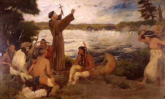
A painting of Father Hennepin discovering Saint Anthony Falls. Father Louis Hennepin with companions Michel Aco and Antoine Auguelle (aka Picard Du Gay) headed north from the area of Illinois after coming into that area with an exploration party headed by René Robert Cavelier, Sieur de La Salle. They were captured by a Dakota tribe in 1680. While with the tribe, they came across and named the Falls of Saint Anthony. Soon, du Lhut negotiated to have Hennepin's party released from captivity. Hennepin returned to Europe and wrote a book, Description of Louisiana, published in 1683, about his travels where many portions (including the part about Saint Anthony Falls) were strongly embellished. As an example, he described the falls as being a drop of fifty or sixty feet, when they were really only about sixteen feet. Pierre-Charles Le Sueur explored the MinnesotaRiver to the Blue Earth area around 1700. He thought the blue earth was a source of copper, and he told stories about the possibility of mineral wealth, but there actually was no copper to be found.
Explorers searching for the fabled Northwest Passage and large inland seas in North America continued to pass through the state. In 1721, the French built Fort Beauharnois on Lake Pepin. In 1731, the Grand Portage trail was first traversed by a European, Pierre La Vérendrye. He used a map written down on a piece of birch bark by Ochagach, an Assiniboin guide. The North West Company, which traded in fur and competed with the Hudson's Bay Company, was established along the Grand Portage in 1783 – 1784.
Jonathan Carver, a shoemaker from Massachusetts, visited the area in 1767 as part of another expedition. He and the rest of the exploration party were only able to stay for a relatively short period, due to supply shortages. They headed back east to Fort Michilimackinac, where Carver wrote journals about the trip, though others would later claim the stories were largely plagiarized from others. The stories were published in 1778, but Carver died before the book earned him much money. Carver County and Carver's Cave are named for him.
Until 1818 the Red River Valley was considered British and was subject to several colonization schemes, such as the Red River Colony. The boundary where the Red River crossed the 49th parallel was not marked until 1823, when Stephen H. Long conducted a survey expedition. When several hundred settlers abandoned the Red River Colony in the 1820s, they entered the United States by way of the Red River Valley, instead of moving to eastern Canada or returning to Europe.The region had been occupied by Métis people, the children of voyageurs and Indians, since the middle 17th century.
Joseph Nicollet scouted the area in the late 1830s, exploring and mapping the Upper Mississippi River basin, the St. Croix River, and the land between the Mississippi and Missouri Rivers. He and John C. Frémont left their mark in the southwest of the state, carving their names in the pipestone quarries near Winnewissa Falls (an area now part of Pipestone National Monument in Pipestone County).
